FALLS ON THE BRAZOS RIVER
The Wild and Mighty Los Brazos De Dios
The Brazos river is the largest river in Texas, and it runs through the center of Falls county. Its full name means the “arms of God”. A padre named the river because it has always given water to thirsty travelers including Indians, hunters, pioneers, Texas Rangers, livestock, and wild game. A crossing place at the Falls of the Brazos River and the fertile soil supported the settlers and the animals in the area.
Hundreds of years ago, the mighty Brazos began dropping red alluvial soil from north and northwest Texas into the shallow valley through Falls County. Heavy rainfalls forced the Brazos to flood and the river channel shifted many times.
When Falls County was named in 1850, the original Falls were reported to be from 12 to 15 feet high, and located about one and one half to two miles Southwest of the present Falls.
In the early 1860's, the mighty Brazos ran wild and shifted completely off course and stopped tumbling over the original Falls. Today, the Brazos river flow is controlled by opening and closing the dams at Possum Kingdom Lake, Lake Granbury and Lake Whitney. The Falls you see today are tame compared to the original Falls. They will be around a long time because the river course can not shift its channel as it did when the original falls disappeared, and Brazos De Dios no longer runs off its course and wild through Falls County.
NATIVE AMERICAN INDIANS ROAMED THE BRAZOS
In 1829, the Falls area did not have a permanent Indian settlement but served as hunting grounds for several tribes, including Waco, Tawakoni, and Anadarko, who were often attacked from the north by the stronger Comanche. The Cherokee arrived in the early 1830s, after the other Indians had been weakened by internal wars in 1829-30. The Cherokees were alone in the area until 1834-35, when Sterling C. Robertson began bringing American settlers to his Robertson's colony.
MRS. SARAH MELVINA MAXWELL REMEMBERS THE OLD FALLS
Sarah Melvina Greer Maxwell, was born in Arkansas in 1846. She remembers: “In the Fall of 1853, our caravan of three ox wagons and two horse wagons set out for ‘somewhere in Texas.’ On November 8, 1853, we pitched camp in Falls County, on Pond Creek, near the present town of Travis. We were afraid the grass might catch on fire, and for this reason camped in the bottom until we could get our houses built.
The old falls is located about one-half mile from the present falls. The public square of the old town of Viesca was about one-half of a mile from the old falls. The beautiful falls were about six feet high. When the river was rising you could hear the falls roaring for miles. The flood of 1866 changed the river's course and ruined the historical “old falls”.
Mrs. Maxwell said “Sumpter Reed lived on the banks of the bayou on the Jones farm at the time of this flood. His house was not far from the old falls on the Brazos. The great flood caved his place off into the river and from that time on the famous fishing place has been called “the Sumpter hole.”
After the Civil War, father died and mother moved with me and my husband to Cedar Springs which was not far from the old Tankoway Indian village and the town site of historical Viesca. The old town of Viesca was the seat of government for the Milam district before Texas became a Republic.
There were two post offices in the state named Cedar Springs. Our little settlement took the name of Viesca after the Viesca that had been at one time near the “old falls” on the Brazos. The name was later changed back to Cedar Springs.
FORT MILAM PROTECTS VIESCA SETTLERS
The first Fort Milam, on the west bank of the Brazos River in central Falls County, was built in 1834 and called Fort Viesca. In December 1835 it was renamed in honor of Benjamin R. Milam, who had died at the siege of Bexar earlier that month. The fort was built for the protection of the settlers of the Robertson's colony community of Sarahville de Viesca at the Falls of the Brazos. It was abandoned during the Runaway Scrape in March 1836 when the settlers fled, giving Viesca the name "the town that died overnight."
As settlers began to return to the area in the spring after the Battle of San Jacinto, Col. Edward Burleson organized three ranger companies to garrison the fort and provide protection to that exposed region. Burleson's volunteers were replaced on the Brazos frontier in the fall by Col. Robert M. Coleman's rangers, and Capt. Thomas H. Barron's company of Coleman's battalion took up garrison duty at Fort Milam on October 1. Barron was relieved by Capt. Daniel Monroe in January 1837. From Font Milam detachments were sent to construct Little River Fort in 1836 and Forts Fisher and Henderson in 1837.
Ranger enlistments began to expire during the late summer of 1837; the Fort Milam garrison, once again under Barron's command, began to evaporate, and the fort soon stood vacant. Its site is now marked only by a stone monument four miles southwest of Marlin on the Churchill Jones farm.
JOHN MCLENNAN RETURNED TO CIVILIZATION
By 1845, Fort Milam had given way to the communities east of the river and to the protection by army posts farther north and northwest. A Grand Peace Council held in 1845 at Torrey's Trading Post on Tehuacana Creek was a colorful event marking the end of Indian troubles. Different tribes from the surrounding country participated, and John McLennan, who was captured as a small boy in the early 1830's in a raid on his family home on Pond Creek west of present Rosebud, was returned to civilization.
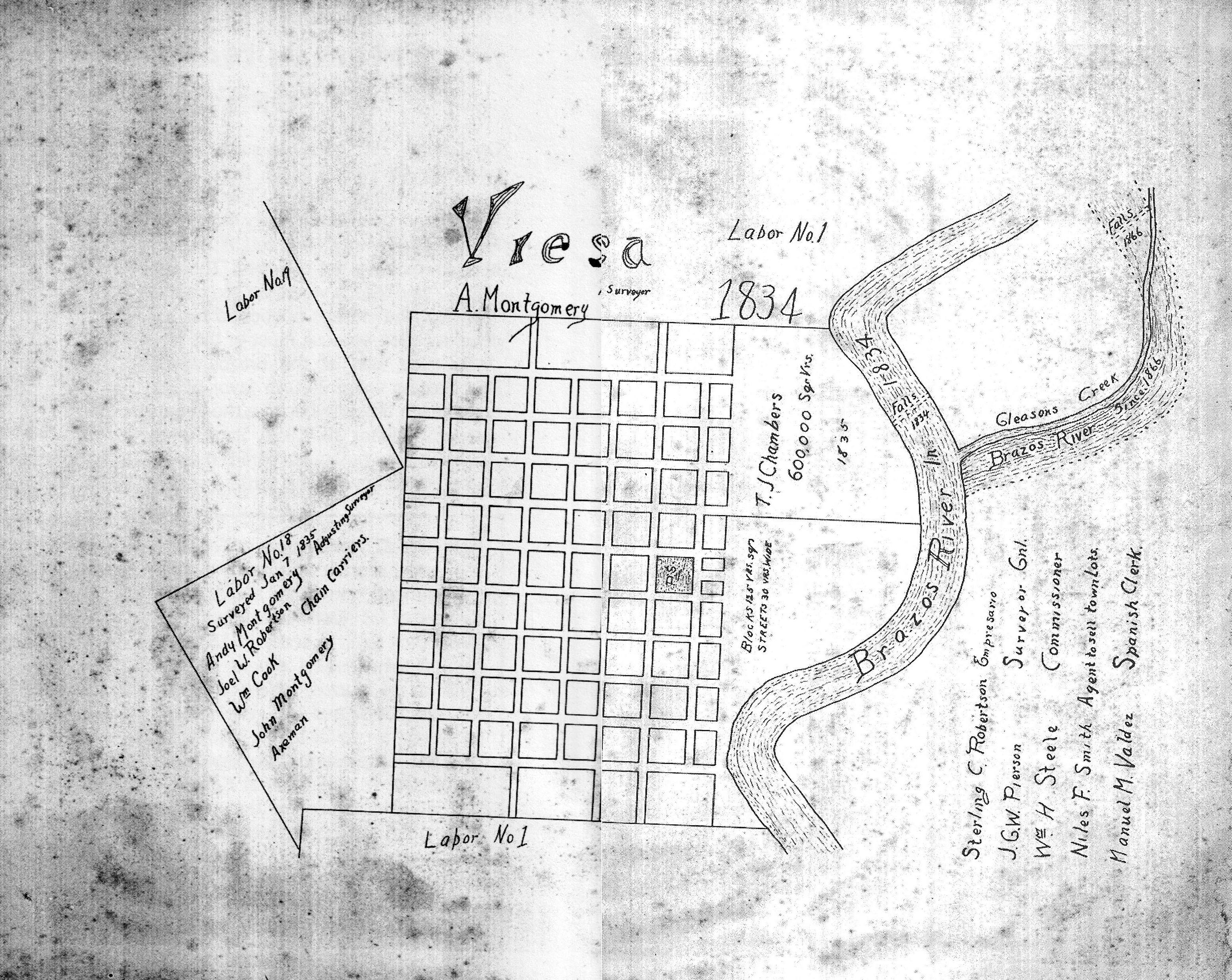
SARAHVILLE DE VIESCA NAMED CAPITAL OF VIESCA DISTRICT, ROBERTSON COLONY
Mr. J. G. W. Pierson, the General Surveyor, designated and laid out a capital in 1834 for the Robertson Colony. It was located atop a hill on the west side of the river, overlooking the Falls, which at that time was a few miles southwest of the present Falls. Sarahville de Viesca was named in honor of Robertson's mother, Sarah Robertson, and Governor Augustin de Viesca, in whose honor the District had also been named. Empresario Robertson lived at Viesca about three years. When he was a delegate to the Convention at Washington-on-the- Brazos, he signed the Declaration of Independence for the Texas Republic.
At the Second Convention at San Felipe in December, 1835, the Viesca District was changed to the Milam District and Viesca became Fort Milam to honor Colonel Benjamin Rush Milam. As late as 1850, it was expected that Fort Milam would be the country seat. It was also considered as a site for the capital of Texas because it was in the center of the state and famous for patriotic service, but after 1852, it was practically deserted.
MARLIN AND MORGAN FAMILIES
By 1837-38, the Marlin and Morgan families returned to the east side of the Brazos River. The Marlin family settled about four miles east of the Falls, and two miles south of the present day Marlin. Their home was called “Fort Marlin" because Mr. John Marlin built his log cabin with notched holes to watch and defend his home. The Morgan Family also settled on the east side of the river, about six miles north of the Falls. By this time Native American Indians had become a constant threat. In June 1837 several men were attacked and one killed. On January 1, 1839, the women and children at Morgan Point, the home of the Morgan's, were killed in what came to be called Morgan's Massacre.
On January 10 ,the same group of Native American Indians attacked Fort Marlin and were repulsed. Six days later the men from Bucksnort attacked the Native American Indians; each side lost ten men, but the Native American Indians won the encounter. Later that year the Texas legislature authorized men to patrol the region, and conflicts with Native American Indians soon ceased. Peace was officially declared in 1845.
MARLIN NAMED COUNTY SEAT OF FALLS COUNTY
On January 28, 1850, the state legislature formed Falls County from Limestone and Milam counties. The Falls on the Brazos gave the county its name. Since Falls County was established its boundaries have not changed. The legislature said Viesca would be the county seat, but the citizens petitioned for another location because most of the residents lived east of the Brazos River. The citizens voted 20-0 in favor of Adams, which officially became the county seat on January 30, 1851. Soon after, the town was renamed Marlin in honor of the Marlin family.
The settlers of Falls County came from the slaveholding South, primarily Mississippi, Tennessee, and Alabama. By the census of 1860 the county had 1,716 slaves (47 percent of the total population) and 504 farms. Falls County relied less on cotton than other Texas counties, harvesting only 2,030 bales in 1860, and relied in- stead on a diverse agricultural economy. Wool was a major crop, with 17,500 pounds produced in 1860, the highest in Falls County history. Cattle was the most important livestock, with 26,310, a total not matched until 1900.
STERLING C. ROBERTSON
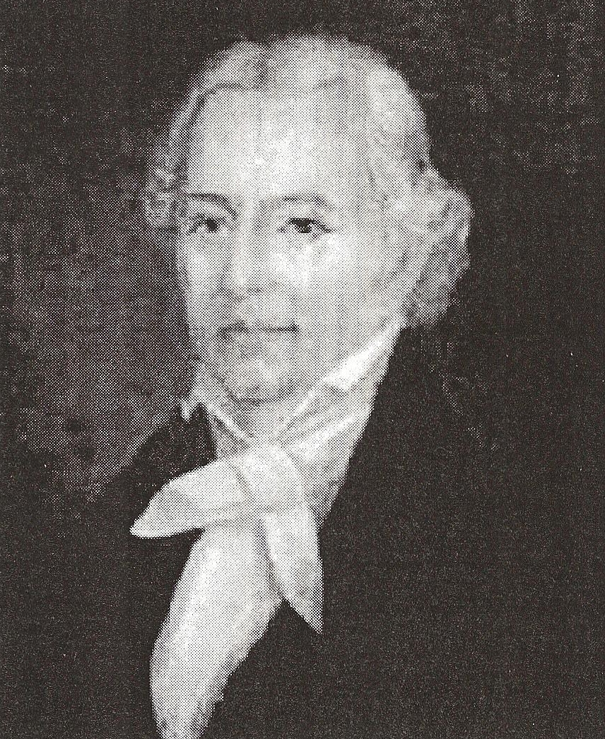 Sterling C. Robertson of Tennessee, under a grant from the Mexican Government, brought about 200 families of his Nashville Company to the Brazos river to settle in 1830. A few of them joined others at the Falls of the Brazos, where in 1834 Robertson assigned J. G. W. Pierson to survey a capitol of his colony at the Falls. Empresario Robertson was a delegate to the General Convention at Washington-on the Brazos and signed the Texas Declaration of Independence in 1836. He lived at the Falls at Viesca at that time. He fought in the Battle of San Jacinto and, after victory, senate in the first Senate of the Republic of Texas.
BUCKSNORT - MENEFEE’S SUPPLY STATION
Bucksnort, originally Jarrett Menefee's Supply Station, was located on a 320-acre prairie owned by Thomas J. Chambers. The settlers established the town in 1837 after the Runaway Scrape about five miles northeast of the old Falls on the Brazos River below the rebuilt Fort Milam. John Marlin’s home lay three miles south and Dr. Allensworth Adams' home a mile directly north. The name Bucksnort was said to have been named by an inebriated customer of the saloon.
Movement to the area was steady in the 1840s, and the settlement grew until it had a school, a general store, a blacksmith shop, a saloon, a racetrack with a stable, and a stagecoach stop that served as a post office. On February 8, the name of the settlement was ?rst officially recognized when the Robertson County Commissioners Court ordered an election to be held at the usual place in Bucksnort at the time of annexation to the United States. Bucksnort residents, however, had already begun to scatter to other communities as the area became safer, and more settlers left as new lands were made available. The community became extinct by about 1852.
GTT
When settlers left, sold or abandoned their homes and farms to migrate to Texas, they would scrawl the initials on their fences "GTT" meaning GONE TO TEXAS!
Learn more about the history of Falls County and The Falls on the Brazos at:
Falls County Historical Museum, Marlin, Tx
Marlin Public Library, Marlin, Tx
D. Brown Library, Rosebud, Tx
Bremond Public Library, Bremond, Tx
Handbook of Texas Online: www.tsha.utexas.edu/handbook/online/
Falls County, Texas TX, county profile : www.epodunk.com/
Falls County, Marlin, Rosebud, Reagan: www.forttumbleweed.com/
Marlin,Texas - The Official Web Site of Marlin and Falls County: www.marlintexas.com/